Pages

Subscribe:

Ads 468x60px

Showing posts with label HILL STATIONS. Show all posts

Monday, 13 August 2012

The Famous Himalayas Mountains

The Famous Himalayas Mountains

Himalayas
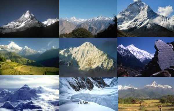
Some of the highest mountains in the world are located in northern India. These are part of the Himalaya mountains. Being the world's highest mountain chain, the Himalayas is characterized by its great height, complex geologic structure, snowcapped peaks, large valley glaciers, deep river gorges, and rich vegetation.
They were given the name Himalaya which means "home of snow", because snow never melts on their high peaks.
The Himalayas form the planet's highest mountain region, containing 9 of the 10 highest peaks in the world. Among these peaks are the world's highest mountain, Mount Everest (8848 m), which is on the Nepal-Tibet border; the second highest peak, K2 or Mount Godwin Austen (8,611 m), located on the border between China and Jammu and Kashmir, the third highest peak, Kanchanjunga (8,598 m) on the Nepal-India border.

The Himalayas can be classified in a variety of ways. From south to north, the mountains can be grouped into four parallel, longitudinal mountain belts,


Shivaliks (Outer Himalayas or Sub-Himalayas)
Himachal ( Lower Himalayas)
Himadri ( Higher Himalayas)
Trans-Himalayas (Tibetan Himalayas)

From west to east the Himalayas are divided broadly into three mountainous regions - the Western Himalayas, the Central Himalayas and the Eastern Himalayas.

Major Himalayan Hill Stations include Gulmarg, Sonamarg, Dharamsala, Ladakh, Simla, Nainital, Kullu, Manali, Dalhousie, Mussoorie, Rishikesh, Amarnath, Gangtok, Kailas Mansarovar, Vaishno Devi, Patni Top etc.

The Himalayas is the world's highest mountain range comprising all top ten of the world's highest peaks. In fact, the Himalayas includes 14 peaks more than 8,000 meters high and some 200 more than 6000 meters.
Read Full Post

Yercaud - Hill Station of Tamil Nadu iNFORMATION

Yercaud - Hill Station of Tamil Nadu

India is full of unexplored tourist places, and Yercaud is one of them. Yercaud is also recognized as small Ooty having countless striking natural beauty spots. This hill station of TN (Tamil Nadu) state is famous for astonishing beauty of nature with healthy climate. Because of its beauty, the British East India Company established the place as first spot for summer vacations.
Peace lovers can spend their holidays in this Indian tourist place. The tourism department of Tamil Nadu is arranging various programs to attract the tourist to Yercaud place. This TN hill station is situated near the busy commercial town Salem, but the station is properly maintained with greenery.
Experts say the hill station was named after the name from a serene lake positioned in the middle of the municipality.

Spots for tourists in Yercaud:
Blown up with numerous visual spots in the region this Indian tourist place is drawing many tourists around the world. Describing few attractions of Yercaud are mentioned below:

Yercaud Lake: positioned at the center of the municipality, this lake is the key tourist spot. May is the month when the spot becomes very special because local people celebrate the festival in such month. The surrounding gardens with trees provide mental peace, though visitors can enjoy the boating at this spot.
Lady's Seat: The spectacular vision of the Ghats, particularly in the night is special thing at Lady’s seat spot. The traffic crossing from the narrow roads through the Yercaud hills is also dissimilar experience for visitors. The rock clusters at south-west face of Yercaud give spectators a panoramic vision the town.
Servarayan Temple: The shrine located on the Servarayan hill is next tourist spot in Yercaud. The narrow cave of the temple having idols of God Servarayan and Deity Kaveri.
Killiyur Falls: waterfall at Kiliyur is popular as atourist spot in Yercaud. Visitors have to travel for 3 kms from Yercaud Lake to reach the waterfall. After the monsoon is the exact time to reach the spot so the tourist must check the weather of Yercaud to make their holidays memorable.
The other two famous spots for tourist in Yercaud are Bear's Cave and Grange. Bear's cave is located close to the Norton Bungalow and Grange the oldest construction in Yercaud done in 1820.

Talking about the finest time to visit this place is February to June, though September to November is also the best time for visitors. November to January is so cold seasons so tourist might get trouble at such period.

Attaining to Yercaud:
By Air: closest airbase is Trichy positioned at just 163 km distance from Yercaud. Some big airports close to this place are Coimbatore and Bangalore.

By Road: road journey to this place is stunning as the curves and various hills are full with natural views. The hill station is just half hour distance from Salem. State and private transport are all time available for Yercaud.

By Rail: closest rail head is Salem's junction connected with almost every big city of the country.
Read Full Post

Sunday, 15 July 2012

Yercaud - Hill Station of Tamil Nadu

Yercaud - Hill Station of Tamil Nadu

India is full of unexplored tourist places, and Yercaud is one of them. Yercaud is also recognized as small Ooty having countless striking natural beauty spots. This hill station of TN (Tamil Nadu) state is famous for astonishing beauty of nature with healthy climate. Because of its beauty, the British East India Company established the place as first spot for summer vacations.
Peace lovers can spend their holidays in this Indian tourist place. The tourism department of Tamil Nadu is arranging various programs to attract the tourist to Yercaud place. This TN hill station is situated near the busy commercial town Salem, but the station is properly maintained with greenery.
Experts say the hill station was named after the name from a serene lake positioned in the middle of the municipality.

Spots for tourists in Yercaud:
Blown up with numerous visual spots in the region this Indian tourist place is drawing many tourists around the world. Describing few attractions of Yercaud are mentioned below:

Yercaud Lake: positioned at the center of the municipality, this lake is the key tourist spot. May is the month when the spot becomes very special because local people celebrate the festival in such month. The surrounding gardens with trees provide mental peace, though visitors can enjoy the boating at this spot.
Lady's Seat: The spectacular vision of the Ghats, particularly in the night is special thing at Lady’s seat spot. The traffic crossing from the narrow roads through the Yercaud hills is also dissimilar experience for visitors. The rock clusters at south-west face of Yercaud give spectators a panoramic vision the town.
Servarayan Temple: The shrine located on the Servarayan hill is next tourist spot in Yercaud. The narrow cave of the temple having idols of God Servarayan and Deity Kaveri.
Killiyur Falls: waterfall at Kiliyur is popular as atourist spot in Yercaud. Visitors have to travel for 3 kms from Yercaud Lake to reach the waterfall. After the monsoon is the exact time to reach the spot so the tourist must check the weather of Yercaud to make their holidays memorable.
The other two famous spots for tourist in Yercaud are Bear's Cave and Grange. Bear's cave is located close to the Norton Bungalow and Grange the oldest construction in Yercaud done in 1820.

Talking about the finest time to visit this place is February to June, though September to November is also the best time for visitors. November to January is so cold seasons so tourist might get trouble at such period.

Attaining to Yercaud:
By Air: closest airbase is Trichy positioned at just 163 km distance from Yercaud. Some big airports close to this place are Coimbatore and Bangalore.

By Road: road journey to this place is stunning as the curves and various hills are full with natural views. The hill station is just half hour distance from Salem. State and private transport are all time available for Yercaud.

By Rail: closest rail head is Salem's junction connected with almost every big city of the country.
Read Full Post

Saturday, 2 June 2012

Ananthagiri Hills Full Information

The breathtaking view of natural scenery at Ananthagiri is amazing experience. This summer special Indian tourist place is considered as ideal spot for nature lovers. The panoramic view from the high hills of Ananthagiri is dissimilar experience for a tourist. This hill station is located in Visakhapatnam, which is full of tourism places.
Driving between the coffee plantations in Ananthagiri refreshes the mood and removes all types of pressures of mind and body. The route with ups and downs is factually surrounded with mango orchards and waterfalls.
Tourist spots at Ananthagiri Hills:
Spending valuable time at Ananthagiri hills allow a tourist to visit the nearby spots of this stunning place. The key marks are Araku Valley, Borra Caves, Bheemuni Patnam Beach, Chandana Yatra, Rama Krishna Beach, Rishikonda Beach and Visakha Utsav. 
Araku Valley: the world-known valley Araku is just 115 km away from Vishakhapatnam city. The pleasant weather, valleys and hills at this spot are spectacular. The nature scene of the valley alive and provide freshness to mind.
Bheemunipatnam Beach: roughly, 25 kms away tourist spot Bheemunipatnam is next added spot for visitors.
Borra Caves: the caves known as Borra are situated at village lying in the hills of Ananthagiri.
Chandana Yatra: the religious people will get chance to see the Chandana Yatra. Reaching Simhachalam is the best spot for such Yatra.
Rama Krishna Beach: the top-most beach near Ananthagiri hills is Rama Krishna Beach.
Rishikonda Beach: one more beach such as Rishikonda is situated just 8 km distance.
Attaining to Ananthagiri Hills:
By Rail: the closest big railhead is Srikakulam to reach this spot, though visitors have to travel for 3 km from the station to reach the hills.
Read Full Post

Tuesday, 22 May 2012

Agumbe - Hill station in Karnataka

Agumbe is the small village and hill station positioned in the Shimoga district, Karnataka, India. Agumbe station is lying in a Thirthahalli taluk. Nature lovers will definitely go to enjoy this place because of greenery hills and amazing valleys created by nature. Agumbe is world-famous for heavy rainfall after Cherrapunji. ARRS (Agumbe Rainforest Research Station) is popular spot for a tourist. This Indian tourist place is the one and only enduring tropical forest research spot of India. This capital of King Cobra snake is known for deep forests as well so those who like wild safari should visit Agumbe.
However, some Naxalite movements have been observed at some close places of Agumbe hill station so tourist might face some security issues as KSP (Karnataka State Police) is been deployed for safety of visitors. Tourist will get check posts at several spots of the Agumbe, but visitors are reaching this stunning hill station frequently.

Key spots for a tourist in Agumbe are sunset point, waterfalls, and deep forests.

Sunset Point: countless visitors are reaching the Agumbe hills to watch the astonishing sunset view. The sundown over the Arabian Sea from the high hills is always special thing. However, the sea is situated at some distance but the view is stunning.


Various waterfalls at Agumbe:

Kunchikal Falls: people believe Kunchikal Falls are the highest waterfalls in India, but the statement is incorrect. The rumour spread over the internet is wrong, but the height of the fall is 455 meters. The measured height of the waterfall is from the sea level not of the waterfall so it is big but not the biggest of India. Though, the fall is amazing and always full with water flow. The Varahi river is special spot for divers and visitors who love to swim.

Barkana Falls: the waterfall known as Barkana is the 10th biggest waterfall of India situated in Agumbe. This fall is formed by Seeta River, and its height is 259 meters.

Onake Abbi Falls: the next waterfall close to Agumbe is Onake. The greenery surrounding the fall is special thing to watch.

Jogigundi: this small water fall is the good place for the picnic, and local people are reaching this 10 to 15 min distance fall at every weekend.
Koodlu Theertha falls: the striking waterfall situated at just 20 km distance from Agumbe is another spot for a tourist. Here visitors can do trekking and enjoy the waterfall.

Attaining Agumbe:
Road: Agumbe is the village close to town Thirthahalli, which means tourists has to reach this town to reach the Agumbe hill station. The NH (National Highway)-13 is directly connected to Agumbe, and the roads are clean and properly managed. Buses from Bangalore are available to attain Agumbe. Reaching Shimoga is also the good way to reach Agumbe.

Rail: Konkan Railway at Udupi is the closest biggest railhead to reach Agumbe.

Air: Closest airbase is Mangalore International Airport, which has direct flights from throughout the world.


Few Interesting Images of Agumbe


Read Full Post

Monday, 14 May 2012

Kibithu - Hill station of Arunachal Pradesh Full Information

Kibithu - Hill station of Arunachal Pradesh

India is having countless places with astonishing natural beauties, which are not hidden from the world. Kibithu is one of the easternmost populated LAC (line of actual control) towns situated on the border of India and China. This small town of AP (Arunachal Pradesh) is covered with stunning hills with amazing beauties created by nature. This town is exactly positioned on the last road of northeast India. The famous Lohit River of China enters in India from Kibithu town.

Kibithu is awarded as most striking and attractive towns of AP serving the tourism with countless rivulets and waterfalls. Kibithu is connected with two other countries through the border as north is connected with China, and East is connected with Myanmar border. However, this town is purely Indian originated place. The big hanging bridge of Kibithu is special experience for visitors, though they require strong nerves for crossing the bridge if the high wind occurs at Lohit River.

Adventurous lovers will get lots of spots in Kibithu for trekking and many other adventure's events. The natural hurdles in Kibithu while trekking towards Taluk pass is the most demanding feature of this town. Taluk pass is situated on the Myanmar border with many natural beauties. Kibithu is also popular for loads of useful herbs, wild life, orchids, hot springs and vintage hanging aircraft due to accidents. Level 5 rafting events are also conducted in Kibithu, which makes this place special for water events.


The spots with hot springs are little difficult to survive as the residents of such areas are facing ample of troubles and difficulties to survive. This could be more challenging for the tourists who love adventure.

Kibithu played the vital role at the time of battle of the Sino-India in 1962. Indian army was attacking and defending the China from Kibithu as it was the entry and launching point of China.

Kibithu is the new melting point of Indo-China friendship and reaching this town is little difficult. Controlling of Kibithu town is done by Tezu, which is the Brigade headquarter.

By Air: Dibrugarh is the closest airport for reaching Kibithu, though the distance is still longer but Dibrugarh is the nearest and safest airbase to reach this town. An individual sanction has to be occupied by the Indian government to reach Kibithu, though visitors can get the permission from Guwahati or Dibrugarh.

By road: local taxi is available on the permit basis so tourist can hire the taxi or cab from Guwahati or Dibrugarh to reach Kibithu. Tourist can also get the permission for Tawang, Parashuram Kund, Bomdila, and Tezu as these are the closest tourist spots of Kibithu.


Impressive Images of Kibithu


Read Full Post

Sunday, 13 May 2012

Harishchandragad - The Hill Station

Harishchandragad - The Hill Station


Harishchandragad - The Hill Station

Harishchandragad is another secret destination for tourism in India. Harishchandragad station is situated in Ahmednagar region, Maharashtra, a big and busy state of India. The huge green hill with an astonishing view of nature is special in this spot. 

This earliest fort is made of Microlithic stone, which makes it different than other forts of India. The ancient scriptures such as Agnipurana, Matsyapurana, and Skandapurana include several references regarding Harishchandragad. As per resources, this fort is originated in 6th century, for the duration of rulers of Kalchuri Empire. The caves available in fort are probably been carved in 11th century. The cliffs are identified as Rohidas and Taramati, those are dissimilar to Ayodhya. 

Enthralling tourist spots:

Saptatirtha Pushkarni: Saptatirtha is the well-built pond on the east side of Vishnu temple of Harishchandragad fort. In recent times the idols of lord Vishnu have been transferred in the caves close to the temple of Harishchandreshwar. Nowadays, lots of trekkers are throwing plastic and creating trouble for tourists. The pond is getting polluted because of wastages thrown by the trekkers and visitors.
Kedareshwar Cave: the next tourist spot in Harishchandragad is Kedareshwar Cave. This spot is positioned in the right side with temple of Harishchandreshwar. The big Shiva ling is the special thing to watch in the cave. The Shivling is surrounded with water, which is a dissimilar occurrence for visitors. The height of Kedareshwar Cave is just seven feet, and the depth of the pond is just 2 to 3 feet. Visitors planning to visit the spot to reach the Shivlinga might get trouble because the water of the pool is frozen. Reaching the cave becomes really difficult in monsoon because of huge flow of water throughout the way.
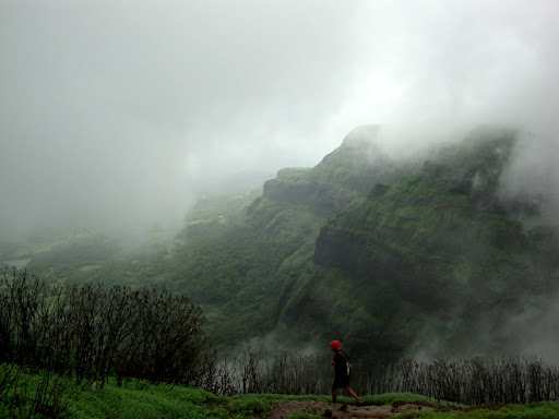
Konkan Kada: also identified as Konkan cliff is one more tourist spot of Harishchandragad. The interesting thing of such area is the cliff that has forever been attracting people from lots of years. The superb sight of the nearby area from the cliff is amazing. The cliff looks like a hangover like snake's hood. The finest thing to watch from this point is an amazing phenomenon erect cloud burst. It looks like a magical wall is created by the clouds, which is growing directly from the cliff edge with no entrance to the landmass area.

Taramati peak: this peak is also recognized as Taramanchi. Taramati is the uppermost peak point of Harishchandragad. Guests can obtain delight of the wild life on this peak as leopards and many wild animals can be seen in the deep forests situated ahead of this peak.
Caves on Harishchandragad: the fort of Harishchandragad is surrounded with caves. Loads of the caves are positioned at the foot of Taramati peak. Such caves are also the place of lodgings. The finest feature of visiting Harishchandragad is visitors can enjoy the beautiful and deep forest and the temples situated inside the forest. The 9.1 meter profound natural cave is located sited the North West side of Harishchandragad fort. Experts say there are still loads of other caves, which are undiscovered yet.


Nageshwar Temple: this is the closest temple to Khireshwar, which is another unique place to visit. The antique structure and varied inventive works at the temple is amazing. Here the visitors will see the carvings and the 1.5 meter long statue of sleeping Lord Vishnu.
Ganesha Temple: another temple in Harishchandragad is Ganesha Shrine. The sculpture is around 16 meters longer from the base. Few caves and very old water tanks are few more spots in this temple.
Attaining Harishchandragad:
Harishchandragad is situated on boundaries of Pune, Thane and Ahmednagar.
To reach this place visitor get 2 to 3 identified routes:
Route from Thane: reaching this hill station require boarding a bus from Kalyan to Nagar. Visitor must get the bus for ‘Khubi Phata’ a small city, and from their visitor should get the private vehicle to reach the Khireshwar village. The distance between Khireshwar and foothills of fort is just 7 kms.
To reach Khireshwar tourist must proceed towards the caves, and water tanks appeared before the fort. Junnar Darwaaja is the tourist spot, and visitors must get the vehicle towards Junnar. The straight route towards Tolar Khind is another better way to reach this fort hill station. However, tourist has to walk for little distance to reach this Indian tourist place. They have to cross the 7 hills and should walk for 2 to 3 hours to attain the Harishchandreshwar temple.
Food service: food is the major concern while going to this favourite Indian tourist place. The arrangements for food done by the villagers are available for winter and summer season only. However, it’s better to arrange the food if the visitors are reaching the destination in monsoon season. The climate situation is not good in monsoon so a tourist might get trouble to avail the food service at fort. 


Few Interesting Pictures


Read Full Post
free counters